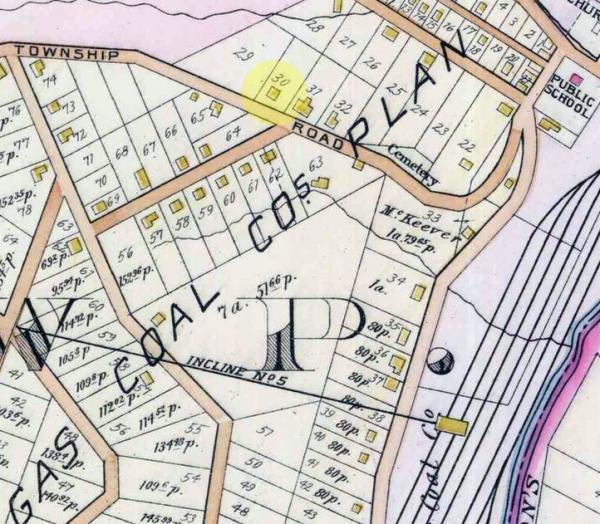
001287: 1903 Plat Map
1903
Detail from a 1903 plat map of Wilkins Township, Allegheny, Pennsylvania showing the location of the Albert and Mary Pohl family homestead, highlighted. The area was also known as #3 Hill. It is in the New York and Cleveland Gas Coal Company plan of lots. What is today known as Harrison Road was then known as Township Road.
"Incline No. 5," shown center, is probably the elevated railroad built to transport coal. In August 1902, the Wilkins Township Board of Commissioners authorized the NY&CGC to build such an incline across the Millerstown to Turtle Creek Road on what was known as #3 Hill in the NY&CGC plan of lots. Linhart was formerly known as Millerstown, so that road would today be Larimer Avenue. That township ordinance implies that #3 Hill was an area and not a specific street.
Source: Digital Research Library, University of Pittsburgh, Pittsburgh, Pennsylvania, Historic Pittsburgh (http://digital.library.pitt.edu/pittsburgh/ : downloaded 16 September 2011), Real estate plat-book of the eastern vicinity of Pittsburgh, Pennsylvania. (Philadelphia: G.M. Hopkins & Co., 1903). Plate 16. http://digital.library.pitt.edu/maps/03vevind.html.
Citation: Mike Voisin, iSeeAncestors (https://iSeeAncestors.com/tree/groups/public/media/si-00007-i546-16.php : revised June 12, 2023), Gallery.
Revised: June 12, 2023
Copyright © 2000-2023 Mike Voisin. All rights reserved.
