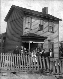
This is a case of genealogical serendipity. I set out to determine the precise location of the house where my maternal great-grandparents, Albert and Mary Pohl, lived. In this picture taken about 1909, the Pohl family posed in front of their house.1
From something unexpected, I uncovered a trail of bread crumbs that led me to their doorstep.
My aunt Mary told me the Pohl family picture was taken in Linhart, Pennsylvania, which is a suburb of Pittsburgh and just north of Turtle Creek, Pennsylvania. The 1930 Federal census2 indicates the family lived on Harrison Road while in 19203 and 19104 they lived on #3 Hill. Were these two different addresses? I was told that #3 Hill is today known as Harrison Road.
Of course the genealogically correct thing to do was to search property records for the chain of ownership. Wading through deed indices and property transfers is tedious and expensive in terms of renting microfilmed records. So I put the project on the back burner, hoping to return to it later.
One day I searched the online news archives of the Pittsburgh Post-Gazette for any articles that mention the Pohl family. I came across a relatively recent article published in July 2006.5 Apparently the Wilkins Township tax assessor was not paying property taxes on property owned by his late father’s estate. It reported his father bought the property from Irene Pohl, a cousin of mine, and granddaughter to Albert and Mary Pohl. Miss Pohl had then recently bought the property herself. That was interesting, although not entirely useful to me. But then the article went on to reveal something incredible.
The land previously figured in a tax matter. In 1947, when it was owned by the estate of Mary Pohl, executor Albert Pohl [her son] sold it for $2,300 to settle the estate’s debts.
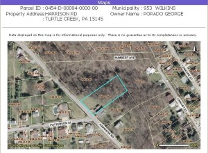
Mary’s husband Albert died in 1931. Mary died in 1944, making it reasonable to assume her son Albert would settle her estate in 1947. This was the very property of my great-grandparents for which I was looking. Armed with the name of the property’s present owner, I visited the Allegheny County website to see if tax assessment records were online. I was able to find the parcel and display a satellite image of its boundaries.6
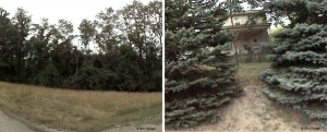
Here it was, at the intersection of Harrison Road with Patterson Street. The house itself is no longer standing. A view from Google Maps (below, left) shows the property today.7 A deep ravine is a short distance from the road. The address is about 230 or 233 Harrison Road. Interestingly, a neighboring house two doors down (below, right) looks very much like the Pohl homestead from the 1910 photograph. Perhaps it is an original structure from that time period.
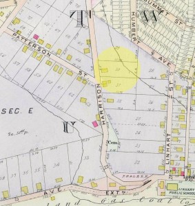
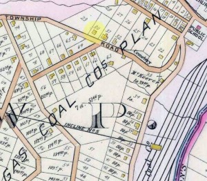
Armed with the location, I next wanted to find an early real-estate plat map that might show the property. At the Historic Pittsburgh website, I found three plat maps published by G. M. Hopkins & Company. The first, in 1915, shows Harrison Road and Patterson Street, with an outline of a home indicated on the property (highlighted).8 The main road at the bottom is Larimer Avenue Extension.
The property boundaries in the plat map matched the tax assessment map perfectly. The second map, in 1903, shows the same area, except that Harrison Road was named Township Road at the time and what would be Patterson Street is unidentified.9
A third map, published in 1895, shows a similar view, although no roads are identified.10 It does indicate however the house was standing on the property as early as 1895, two years after the Pohl family immigrated to America in 1892/1893. Precisely when the Pohl family occupied the house must still be determined by tracing the deed records.
I continued to follow my trail of bread crumbs. In the 1903 map above, “Incline No. 5” caught my eye. It appears bottom, center. I read in the township history provided at the Wilkins Township website11 that an elevated railroad was to be built to transport coal. In August 1902, the Wilkins Township Board of Commissioners authorized the New York and Cleveland Gas Coal Company (NY&CGC) to build such an incline across the Millerstown to Turtle Creek Road on what was known as #3 Hill in the NY&CGC plan of lots.12 Linhart, Pennsylvania was formerly known as Millerstown, so that road would today be Larimer Avenue. That township ordinance implies that #3 Hill was an area and not a specific street.
In a round-about way I found the precise location of the Pohl family homestead. I started with an early picture of the house and family, a clue from a relative, and Federal census records. When I later happened upon an obscure newspaper article that mentioned the present owner, it led to a tax map, and a view from Google Maps, then to three real estate plat maps. One plat map showed an incline railroad. A 1902 Wilkins Township ordinance confirmed the area was #3 Hill.
Harrison Road, formerly Township Road, was therefore part of #3 Hill, which was near Linhart, formerly Millerstown, in Wilkins Township, Allegheny County, Pennsylvania. A circuitous yet fortuitous find indeed.
Footnotes- The original is in the possession of Mike Voisin (mounted on cardboard, 5-15/16 by 6-15/16 inches).
- NARA Microfilm, Series T626, Roll 1992, Page 155A and 155B, Wilkins Township, Allegheny County, Pennsylvania.
- NARA Microfilm, Series T625, Roll 1530, Page 207A, Wilkins Township, Precinct 1, Allegheny County, Pennsylvania.
- NARA Microfilm, Series T624, Roll 1298, Page 251A and 251B, Wilkins Township, District 1, Allegheny County, Pennsylvania.
- Bill Heltzel, “Official Not Paying Taxes on Estate Land,” Article, Pittsburgh Post-Gazette, 27 July 2006; online archives (http://post-gazette.com : downloaded 31 May 2011). http://www.post-gazette.com/pg/06208/708783-56.stm.
- Allegheny County Pennsylvania (http://county.allegheny.pa.us/ : downloaded 6 April 2009), Office of Property Assessments, Parcel 0454-D-00084-0000-00, Harrison Road, Turtle Creek, Pennsylvania.
- Google Maps, Street View, 196-230 Harrison Road, Turtle Creek, Pennsylvania (http://maps.google.com : downloaded September 17, 2011).
- Digital Research Library, University of Pittsburgh, Pittsburgh, Pennsylvania, Historic Pittsburgh (http://digital.library.pitt.edu/pittsburgh/ : downloaded 16 September 2011), Real estate plat-book of the eastern vicinity of Pittsburgh, Pennsylvania. (Philadelphia: G.M. Hopkins & Co., 1915). Plate 15. http://digital.library.pitt.edu/maps/20091022-hopkins.html.
- Digital Research Library, University of Pittsburgh, Pittsburgh, Pennsylvania, Historic Pittsburgh (http://digital.library.pitt.edu/pittsburgh/ : downloaded 16 September 2011), Real estate plat-book of the eastern vicinity of Pittsburgh, Pennsylvania. (Philadelphia: G.M. Hopkins & Co., 1903). Plate 16. http://digital.library.pitt.edu/maps/03vevind.html.
- Digital Research Library, University of Pittsburgh, Pittsburgh, Pennsylvania, Historic Pittsburgh (http://digital.library.pitt.edu/pittsburgh/ : downloaded 16 September 2011), Real estate plat-book of the eastern vicinity of Pittsburgh, Pennsylvania. (Philadelphia: G.M. Hopkins & Co., 1895). Plate 16. http://digital.library.pitt.edu/maps/20090121-hopkins.html.
- Wilkins Township, PA, History of Wilkins Township (http://www.wilkinstownship.com/PDF/Wilkins%20Township%20History.pdf : downloaded 9 September 2011).
- Wilkins Township Board of Commissioners, Wilkins Township, Allegheny, Pennsylvania, Wilkins Township (http://www.wilkinstownship.com/ : downloaded 9 September 2011), An ordinance granting to the New York and Cleveland Gas Coal Company the right to erect an incline, Ordinance 13, Page 15, Historical Ordinances 05/04/1901 to 01/12/1923.

