

Western Pennsylvania and the vicinity of Pittsburgh was a wilderness frontier at the time of the Revolutionary War and for years afterward. The few settlers who ventured into this area not only endured the hardships of pioneer life, but they also had hostile encounters with Native Americans.
In his work, History of Indiana County Pennsylvania: 1745-1880, editor Walter F. Arms provides a map of the county. 1 He indicates the location of two blockhouses within Buffington Township.

Although the structures are numbered 4 and 5, there is no further description of them in the text. Blockhouse 5 was near Dilltown on Black Lick Creek, probably close to Bracken’s grist mill. Blockhouse 4 appears to be near the property of my fourth great-grandparents, John and Margaret (McFarland) Stewart.
Other sources identify this as McCartney’s blockhouse. Joseph McCartney was another early settler in the area, and perhaps one of the earliest.
McCartney’s Blockhouse—Erected probably in the latter years of the Revolutionary War, in what is now Buffington Township, Indiana County. 2
It turns out my Stewart ancestors were nearby neighbors of Joseph McCartney. They probably used this very blockhouse for protection and defense against Indian attacks.
A blockhouse was a small “fort” where settlers took refuge when threatened. It was nothing more than a cabin, usually with one and half or two stories. Sometimes the upper story had an overhang of a couple feet around its perimeter. This provided a gap that enabled its occupants to defend against attackers climbing the wall below.
Here are two representative depictions of blockhouses. The first was built in 1771 by Capt. Lazarus Stewart (no relation) in Hanover Township, Luzerne County, in northeastern Pennsylvania. 3

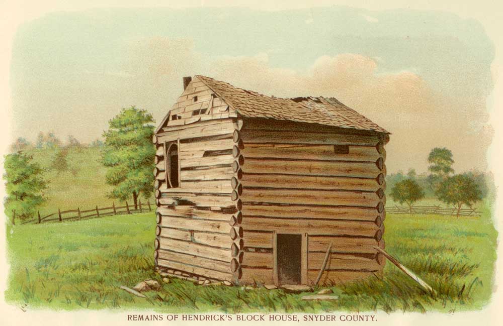
The second depiction shows a different building style. It was built about 1770 by the Hendricks family in Middlecreek Township, Snyder County, in central Pennsylvania. 4
There is no description of what McCartney’s blockhouse actually looked like. However I can determine approximately where it was located. Below is a composite of several land surveys, starting with my ancestor John Stewart’s land on the left. 5 It shows the relative position of neighboring properties loosely pieced together. Joseph McCartney had two properties not far from the Stewart property.

The larger 307.5 acre tract must be Joseph McCartney’s original land. The warrant to survey the property was dated 7 December 1773, so perhaps he was in the area in 1773 or before. Note at that time this was in Westmoreland County and it would become Indiana County in 1803.
Survey to Joseph McCartney on the 29th day of April 1776, the above described tract of three hundred & seven acres & an half acre & allowance of six p. cent situate on the Reich hill on the waters of Black Lick creek in Westmoreland County. By warrant of the 7th day of December 1773. Joshua Elder D.S. [Deputy Surveyor] 6
Several years later, Joseph McCartney obtained 216.5 acres of adjoining land. That warrant was dated 8 February 1785.
Surveyed to Joseph McCartney on the 8th day of May 1786, the above described tract of Two hundred & sixteen acres & an half acre and allowance of six p. cent. Situate on the waters of Black Lick adjoining his other Land & extending along the Ridge towards Braken’s & including an Improvement in Westmoreland County. By Warrant of the 8th day of Feby, 1785. Joshua Elder D. S. 7
This is consistent with an account that Joseph McCartney first settled here before the Revolutionary War, but was driven away by Indians, only to return years later. During the war, Native Americans had an incentive to kill settlers due to a bounty paid by the British for American scalps. 8
[Joseph McCartney] was a surveyor and school teacher and was a native of Ireland. He settled on the tract of which the Benson Dill farm is [in 1880] a part, some time previous to the Revolution, and was driven away by the Indians. He did not return till about the closing year of that struggle. He and his neighbors erected a blockhouse on this place, its situation being near the site of the old residence. 9
This implies the blockhouse was built on the older, 307.5 acre parcel. Apparently his first five children were born in Franklin County, Pennsylvania, east of the Allegheny Mountains. 10 So he lived in Franklin County at least between their birth years of 1774 and 1782. 11 His next daughter, Catherine, was probably born in 1784, perhaps after he returned to Westmoreland.
An 1871 map indicates “Site of Block House Built in 1790” (marked with a #, and highlighted below). 12 It appears to be on the original Joseph McCartney tract.

Notice both the “J. Stewart” farm and the “J. Stewart, Sr.” farm. At the time of this map, 1871, “J. Stewart” was John Stewart, son of Major James Stewart and Mary (Graham) Stewart. Major James Stewart was a son of the original settlers, John and Margaret (McFarland) Stewart and that would have been the original Stewart tract. “J. Stewart, Sr.” was Major James Stewart. His other son, James Stewart, also lived with him. 13
The county history goes on to state:
There was a blockhouse or fort on the Joseph McCartney farm near where the East Union United Presbyterian church now stands. 14
Notice the church highlighted on the map (“U.P. CH.”), which was the East Union United Presbyterian Church. Today it is the Gospel Community Church. The cemetery (“Cem”) was then known as the McCartney burial ground and today is known as the East Union/McCartney Cemetery. Joseph McCartney is buried there along with many of my Stewart ancestors. Although, the graves of the original settlers John and Margaret Stewart have not been identified. 15


Historical accounts are vague. Most sources borrow from still earlier histories and newspaper articles, and they all probably indirectly reference a few unsubstantiated sources. Generally they say McCartney’s blockhouse was constructed during the period from the end of the Revolutionary War (1783) up to 1790. Early settlers generally left the area due to hostile Indian encounters and returned years later. It wasn’t until 1795, after General Anthony Wayne’s campaign and the Treaty at Greenville, Ohio, that most settlers returned permanently.
I assume Joseph McCartney returned before 1785 when his second tract of land was surveyed. But a survey does not necessarily mean he was actually in the area. Charles Stewart, brother to my fourth great-grandfather, John Stewart, also had land surveyed in 1785. His land was adjacent to what would later be his brother John’s land.
Survey’d to William Holmes & Charles Stewart on the 22d day of September 1785 the above described tract of three hundred & sixty seven acres & three quarters of an acre & allowance of six pcent Situate on the waters of the Black Lick Creek on the west side of Brackens Mill creek about two miles from the mill house below & adjoining land Surveyed for Isaiah Jones & Company in Westmorland County by warrant of the 29th day of August 1785. Joshua Elder D.S. [Deputy Surveyor] 16
Accounts say the brothers, John and Charles Stewart, accompanied each other here after the Revolutionary War, but that does not necessarily mean they arrived at the same time. 17 John most likely arrived by September 1793. When he applied for his land patent, his neighbor Joseph McCartney stated John had been there since September 1793, and he had made improvements, and grown grain since then. 18 John’s survey warrant was dated 13 February 1797.
Surveyed to John Stewart the 31st Day of March 1797 the above described Tract of Two hundred & ninety two acres and forty one perches [a rod, 1 rod is 5.5 yards] & Allowance of 6 pr cent situate on the waters of Black Lick adjoining Lands of Charles Stewart[,] William Shaft & others including his improvement[,] in Wheatfield Township[,] Westmoreland County by Warrant of the 13th Day of Febr in the Year 1797. James Ross, D.S. 19
The 1790 federal census confirms John’s later arrival. 20 Both Charles Stewart and William Holmes were listed in Wheatfield Township, but John Stewart was not. Thus he was likely not there in 1790.
A blockhouse was constructed for the mutual protection of neighbors. Since Charles Stewart was there, he likely helped build the McCartney blockhouse along with other close neighbors. John Stewart, arriving later, likely used it after it had been constructed. The blockhouse may actually have been used for defense against Indian attacks. There are several accounts of hostilities with Native Americans during this period, 1783 to 1795. The county history describes a recollection of Joseph McCartney’s oldest child. His daughter Jeannet (1774-1821), probably a teenager at the time, remembered being in the blockhouse during an attack.
Jeannet used to watch at the portholes of the blockhouse, and ran bullets for the men while fighting the Indians. 21
It is unclear if this actually happened or it is merely family lore. However another account mentions an attack in 1791 three townships to the west:
Some time in 1791, David Peelor was killed by Indians while working on his farm, a short distance from his blockhouse in Armstrong Township, in the western part of Indiana County. 22
Still another source indicates that in general, the area was relatively quiet:
After the close of the War, this section [west of the Allegheny Mountains] became in its turn a frontier, and there were various places intended for temporary refuge constructed out of the houses of the settlers of that time; but while the apprehensions were great at times during the Indian wars of 1790 and ’93, yet no serious depredations were committed by the few detached parties of savages who marauded through the region nearest the Allegheny. 23
When and to whom were hostile encounters reported and how did they come to be recorded in the history books? It is plausible not every such encounter was reported. So even if there were no accounts published, they still could have occurred.
John Stewart reportedly fought in the “Indian Wars” and was severely wounded in the breast. 24 The Indian Wars were not organized campaigns and battles that fit the definition of modern warfare. It was a period known as the 400-years war, and can more correctly be described as Native American resistance to European encroachment. 25 It is unclear where or when John Stewart fought and was wounded. Perhaps it was during an attack at the McCartney blockhouse.
In summary, I identified an obscure reference on an 1880 map as the blockhouse of Joseph McCartney. He in turn was a close neighbor of my ancestors, John and Margaret (McFarland) Stewart. Reports suggest this blockhouse was at least used for protection, if not for defense against actual Indian attacks. It is another testament to the hardships of pioneer life on the frontier of Western Pennsylvania following the Revolutionary War.
Footnotes
- Walter F. Arms, editor, History of Indiana County Pennsylvania: 1745-1880, (Newark, Ohio: J. A. Caldwell), 1880, frontispiece.
- C.H. Sipe, The Indian wars of Pennsylvania, (Harrisburg: The Telegraph Press), 1929, (https://archive.org/details/indianwarsofpenn00sipe : downloaded 8 March 2017), page 759.
- Thomas Lynch Montgomery, editor, Report of the Commission to locate the site of the frontier forts of Pennsylvania, (Harrisburg: W. M. Stanley Ray), 1916; digital images, Internet Archives, (https://archive.org/details/reportofcommis01comm : downloaded 8 March 2017), page 450. Image from US GenWeb Archives (http://www.usgwarchives.net/pa/1pa/1picts/frontierforts/frontierforts.htm : downloaded 8 March 2017).
- Thomas Lynch Montgomery, editor, Report of the Commission to locate the site of the frontier forts of Pennsylvania, (Harrisburg: W. M. Stanley Ray), 1916; digital images, Internet Archives, (https://archive.org/details/reportofcommis01comm : downloaded 8 March 2017), page 618. Image from US GenWeb Archives (http://www.usgwarchives.net/pa/1pa/1picts/frontierforts/frontierforts.htm : downloaded 8 March 2017).
- Pennsylvania, “Copied Surveys, 1681-1912,” database and digital images, Pennsylvania State Archives, Land Records (http://www.portal.state.pa.us/portal/server.pt/community/state_archives/2887 : downloaded 9 December 2009), RG-17, Series #17.114, Copied Survey Book C-206, Page 221 and reverse, John Stewart, http://www.phmc.state.pa.us/bah/dam/rg/di/r17-114CopiedSurveyBooks/Books%20C1-C234/Book%20C206/Book%20C-206%20pg%20441.pdf; Pennsylvania Historical and Museum Commission, Bureau of Archives and History.
- Pennsylvania, “Copied Surveys, 1681-1912,” database and digital images, Pennsylvania State Archives, Land Records (http://www.phmc.state.pa.us/bah/dam/rg/di/r17-114CopiedSurveyBooks/r17-114MainInterfacePage.htm : downloaded 8 March 2017), RG-17, Series #17.114, Copied Survey Book A-3, Page 175 and reverse, Joseph McCartney, http://www.phmc.state.pa.us/bah/dam/rg/di/r17-114CopiedSurveyBooks/Book%20%20A1-A89/Book%20A-03/Book%20A-03%20pg%20352.pdf; Pennsylvania Historical and Museum Commission, Bureau of Archives and History.
- Pennsylvania, “Copied Surveys, 1681-1912,” database and digital images, Pennsylvania State Archives, Land Records (http://www.phmc.state.pa.us/bah/dam/rg/di/r17-114CopiedSurveyBooks/r17-114MainInterfacePage.htm : downloaded 8 March 2017), RG-17, Series #17.114, Copied Survey Book A-57, Page 195 and reverse, Joseph McCartney, http://www.phmc.state.pa.us/bah/dam/rg/di/r17-114CopiedSurveyBooks/Book%20%20A1-A89/Book%20A-57/Book%20A-57%20pg%20390.pdf; Pennsylvania Historical and Museum Commission, Bureau of Archives and History.
- C.H. Sipe, The Indian wars of Pennsylvania, (Harrisburg: The Telegraph Press), 1929, (https://archive.org/details/indianwarsofpenn00sipe : downloaded 8 March 2017), page 508.
- Walter F. Arms, editor, History of Indiana County Pennsylvania: 1745-1880, (Newark, Ohio: J. A. Caldwell), 1880, page 541.
- Walter F. Arms, editor, History of Indiana County Pennsylvania: 1745-1880, (Newark, Ohio: J. A. Caldwell), 1880, page 541.
- The Church of Jesus Christ of Latter-day Saints, “Ancestral File,” database, FamilySearch (https://familysearch.org/ark:/61903/2:1:MWFZ-L8K : accessed 2017-03-09), entry for Joseph MC CARTNEY.
- “State and County Maps: Pennsylvania: County Maps and Atlases,” map images, USGenWeb Archives, United States Digital Map Library (http://www.usgwarchives.org/maps/pa/county/: downloaded 9 December 2009), Map of Buffington Township, Indiana, Pennsylvania; citing Atlas of Indiana County Pennsylvania, (New York: F.W. Beers & Co., 1871).
- John Stewart was later convicted of horse theft in 1877 and his farm was sold to cover restitution. A description of the property indicates his neighbors and thus his was the land marked “J. Stewart” on the 1871 map. The 1870 federal census shows James Stewart, Sr. and his son James Stewart listed in the same household, presumably that marked “J. Stewart, Sr.” on the map.
- Walter F. Arms, editor, History of Indiana County Pennsylvania: 1745-1880, (Newark, Ohio: J. A. Caldwell), 1880, page 541.
- East Union-McCartney Cemetery, Find-a-Grave (https://findagrave.com/cgi-bin/fg.cgi?page=cr&GSvcid=554556&GRid=133512403&CRid=2548750& : downloaded 8 March 2017).
- Pennsylvania, “Copied Surveys, 1681-1912,” database and digital images, Pennsylvania State Archives, Land Records (http://www.portal.state.pa.us/portal/server.pt/community/state_archives/2887 : downloaded 9 December 2009), RG-17, Series #17.114, Copied Survey Book C-82, Page 218 and reverse, William Holmes and Charles Stewart, http://www.phmc.state.pa.us/bah/dam/rg/di/r17-114CopiedSurveyBooks/Books%20C1-C234/Book%20C082/Book%20C-082%20pg%20438.pdf; Pennsylvania Historical and Museum Commission, Bureau of Archives and History.
- Joshua Thompson Stewart, Indiana County, Pennsylvania: Her People, Past and Present, 2 Volumes (Chicago, Illinois: J. H. Beers, 1913); digital images, The Internet Archive, Text Archive (http://www.archive.org/details/indianacountypen01stew : downloaded December 9, 2009), page 703.
- Pennsylvania, Land Warrants and Applications, 1733-1952 [database on-line]. Ancestry.com. Provo, UT, USA: Ancestry.com Operations, Inc., 2012. John Stewart, Wheatfield Township, Westmoreland, Pennsylvania, 1797.
- Pennsylvania, “Copied Surveys, 1681-1912,” database and digital images, Pennsylvania State Archives, Land Records (http://www.portal.state.pa.us/portal/server.pt/community/state_archives/2887 : downloaded 9 December 2009), RG-17, Series #17.114, Copied Survey Book C-206, Page 221 and reverse, John Stewart, http://www.phmc.state.pa.us/bah/dam/rg/di/r17-114CopiedSurveyBooks/Books%20C1-C234/Book%20C206/Book%20C-206%20pg%20441.pdf; Pennsylvania Historical and Museum Commission, Bureau of Archives and History.
- 1790 United States Federal Census [database on-line]. Ancestry.com. Provo, UT, USA: Ancestry.com Operations, Inc., 2010. Wheatfield Township, Westmoreland, Pennsylvania, pages 44-46.
- Walter F. Arms, editor, History of Indiana County Pennsylvania: 1745-1880, (Newark, Ohio: J. A. Caldwell), 1880, page 541.
- C.H. Sipe, The Indian wars of Pennsylvania, (Harrisburg: The Telegraph Press), 1929, (https://archive.org/details/indianwarsofpenn00sipe : downloaded 8 March 2017), page 696.
- George Dallas Albert, Report of the Commission to Locate the Site of Frontier Forts of Pennsylvania, Volume 2, The Frontier Forts of Western Pennsylvania (Clarence M. Busch, State Printer of Pennsylvania, 1896); digital images, Internet Archives, (http://www.archive.org/details/reportofcommissi02comm : downloaded June 27, 2011), pages 444-445.
- Joshua Thompson Stewart, Indiana County, Pennsylvania: Her People, Past and Present, 2 Volumes (Chicago, Illinois: J. H. Beers, 1913); digital images, The Internet Archive, (http://www.archive.org/details/indianacountypen01stew : downloaded December 9, 2009), page 703.
- Carl Waldman, Atlas of the North American Indian: Revised Edition (New York, New York: Facts On File, Inc., 2000), page 103.
Dear Mike,
I am doing some research on my family tree. We share some interesting mutual historical facts. For instance, my gg grandfather eventually bought the “J McCartney Heirs” farm. He is buried in the East Union/McCartney cemetery, also.Also, I have the farm bill of sale and it speaks to bordering the Stewart farm.
How might I communicate with you if you are interested.
David Wilson
Johnstown, Pa
Sounds interesting David. You can contact me at MikeVoisin@iSeeAncestors.com.
UPDATE: Newly discovered evidence indicates John Stewart arrived in the area in September 1793. This was likely after the McCartney blockhouse was built. Joseph McCartney himself vouched that John Stewart had been on what would become his property since September 1793.