My fourth great-grandparents, John and Margaret Stewart, were two of the first settlers in what would eventually become Buffington Township, Indiana County, Pennsylvania. John Stewart married Margaret McFarland in 1788 and by 1796 they had a son, my third great-grandfather, James Stewart.
I describe here how I used records available at the Pennsylvania Historical and Museum Commission (PHMC)1 and Google Earth to pinpoint the location of the original Stewart homestead.
Online records at PHMC indicate a warrant to survey a tract of land named “Cornfield” for John Stewart was issued February 13, 1797.2 The resulting survey was conducted March 31, 1797 and filed (returned) March 26, 1799.3 A subsequent land patent was issued March 28, 1799.4 A patent confers ownership of land from the Commonwealth to a private person.
The description of the property in the land patent is given in metes and bounds:
Thence by land of Nathaniel Bryan. North Seventy deg,s West Sixty four perches to a Post. North sixty degrees West one hundred and four perches to a [Chestnut]….
Certainly I cannot find the post, or the chestnut tree after 214 years. The notation “North 70 degrees West 64 perches” describes a boundary line segment. Face north, then turn 70 degrees to the west and measure 64 perches. Since north is zero degrees and west is 270 degrees, the actual compass bearing is 290 degrees (360 – 70 = 290). Lengths were given in perches. A perch is a British term for a rod, common in surveying. A rod is 5.5 yards or 16.5 feet.
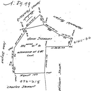
John Stewart’s land is also recorded in the survey copy books. These were copied around the turn of the twentieth century from the original surveys. It gives a diagram of the property, which is approximately to scale.
I had the shape of the Stewart homestead, but not where it was actually located. The survey only indicates it was near Black Lick Creek:
Surveyed to John Stewart the 31st Day of March 1797 the above described Tract of Two hundred & ninety two acres and forty one perches & Allowance of 6 pr cent situate on the waters of Black Lick adjoining Lands of Charles Stewart[,] William Shaft & others including his improvement in Wheatfield Township Westmoreland County by Warrant of the 13th Day of Febr in the Year 1797.
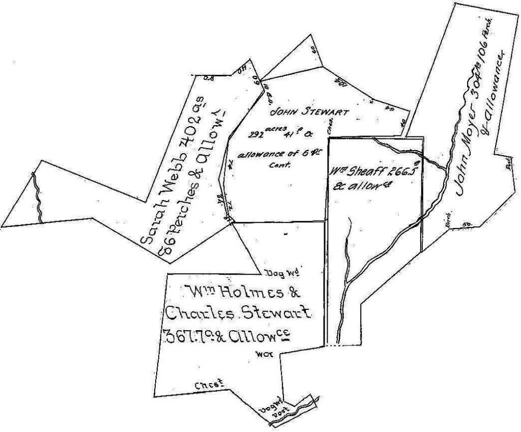
I therefore examined the surveys of neighboring properties. The survey books provide the names of adjacent property owners and the volume and page of their surveys. In my case John Stewart’s brother Charles had land immediately adjacent. His survey indicates, “Situate on the waters of the Black Lick Creek on the west side of Brackens Mill creek about two miles from the mill house….” Others provided more clues like, “Situate on Braken’s mill creek about two miles from Braken’s house” and “Situate on the head waters of Brakins Mill run.”
Using a graphics program, I pieced together several of these surveys. Each survey can have a slightly different scale and orientation. They also cover a period ranging over 100 years so properties could have been re-sized as they changed ownership. However the shapes of the property boundaries do line up closely enough to depict relative orientation.
I even continued the chain of property surveys down to Bracken’s Mill on Black Lick Creek (not shown here). I’m confident the streams shown on the William Sheaff and John Moyer properties are the head waters of Bracken’s Run. And the John Stewart property is adjacent to these properties. So that gives the general location of the homestead.
I used old maps from 1817, 1856 and 1871 to locate Bracken’s Run, which terminated at Black Lick Creek at present-day Dilltown, Pennsylvania. It is called Madris Run today. I followed that creek northward on a present-day map and determined its origin, or head waters.
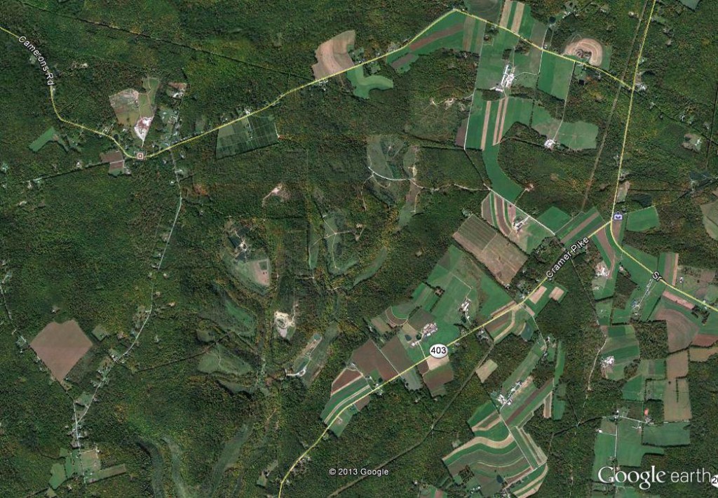
Now to more precisely locate the Stewart homestead. I used Google Earth because it has a feature to add overlays of old maps to the modern imagery it displays. First I found the general area in question:
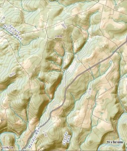
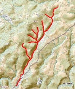
However it is difficult to see or follow Madris Run, formerly Bracken’s Run, in this imagery. I used a topographical map of the area from the National Map website5. You can either download a high-resolution image or take a screen capture once you zoom into the area you want:
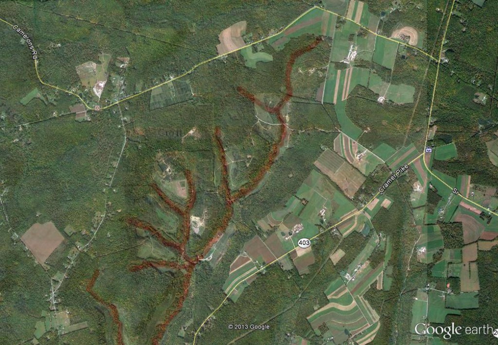
It is still difficult to follow Madris Run, so I edited the image to draw a red line along the creek bed:
I used this image as an overlay in Google Earth, and matched the present-day roads to properly position it.
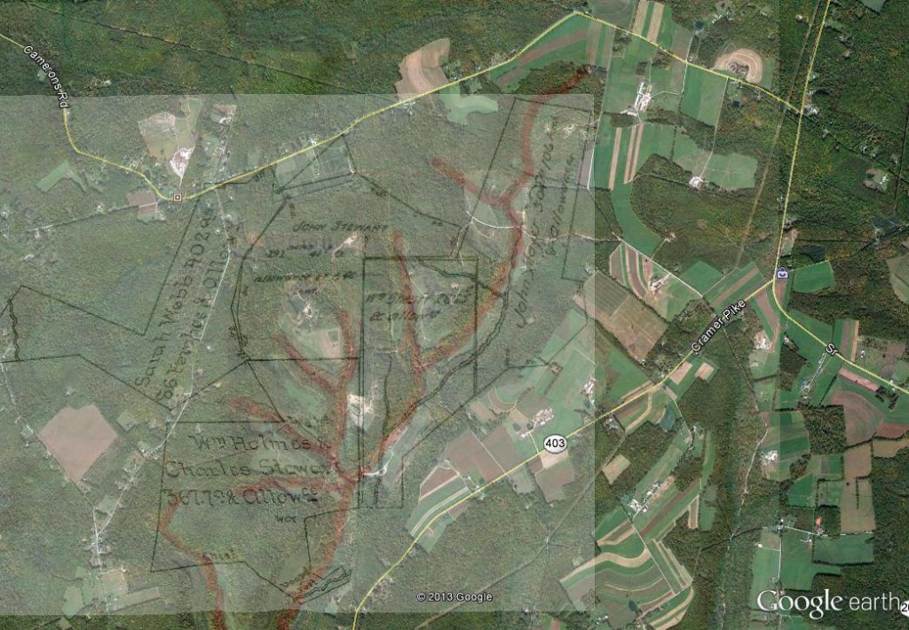
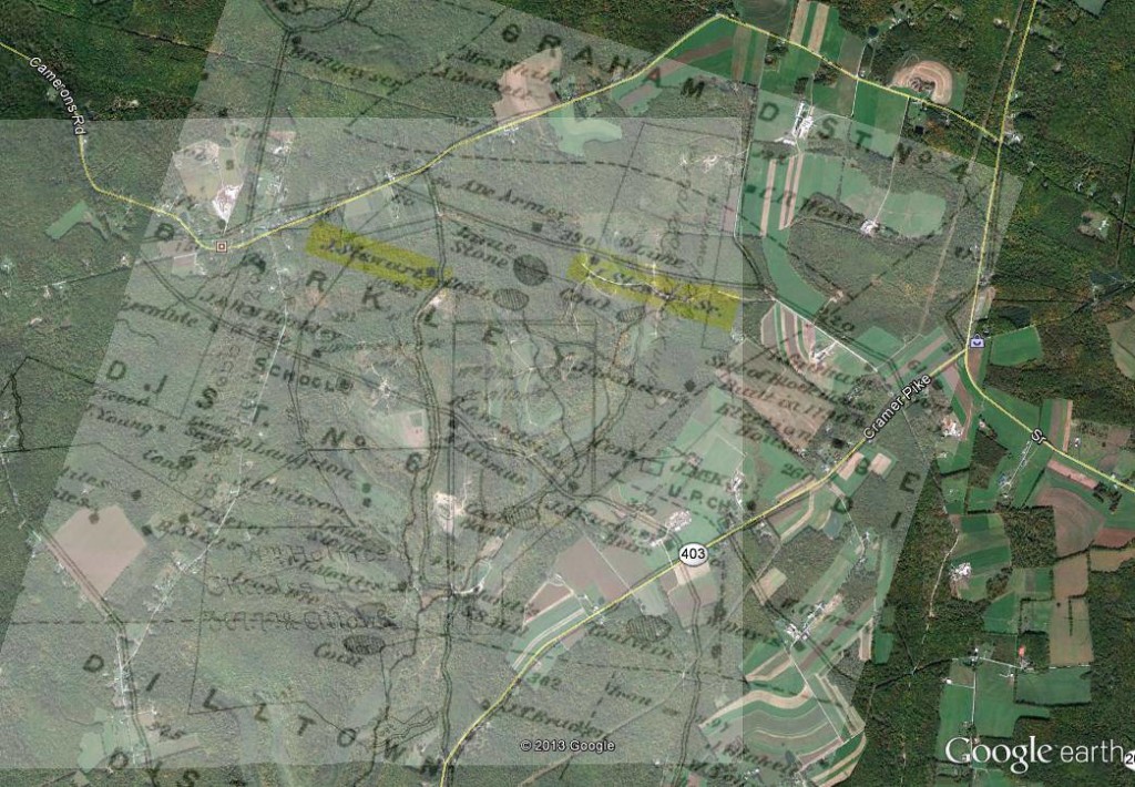
I then added my combined survey image as another overlay. This time I tried to match the sketch of Bracken’s Run to the red line I marked for Madris Run. The surveys are only an approximation so I didn’t expect them to fit the actual geography precisely. In fact the northern edge of the Moyer property looks like it would fit at the intersection of the two roads a little further north.
Two features helped me select a better spot after I aligned the creek beds. One was the line segment in the survey that is exactly north-south. I aligned this line to the north indicator in Google Earth. Secondly, the triangle at the top of the survey indicates one side is 60 perches. The secondary road coming off Camerons Road happens to be about 60 rods long, as measured in Google Maps. And luckily in my case that road is named Stewart Hollow Road.
It is still not a definitive match, but the circumstantial evidence is compelling. The north-south boundary line is actually north-south on the map, the triangular section lines up with Stewart Hollow Road, and the southern-most portion of Charles Stewart’s property touches Madris Run as indicated in that survey. This shows the scale and orientation are approximately correct, although I suspect the boundaries could be adjusted slightly to fit the present-day tree lines and property boundaries.
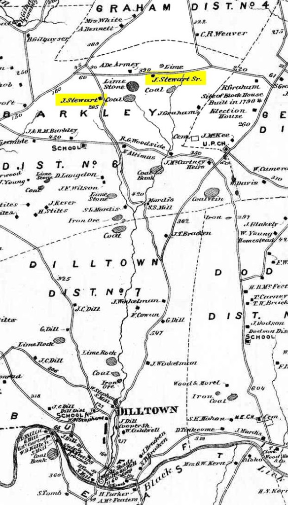
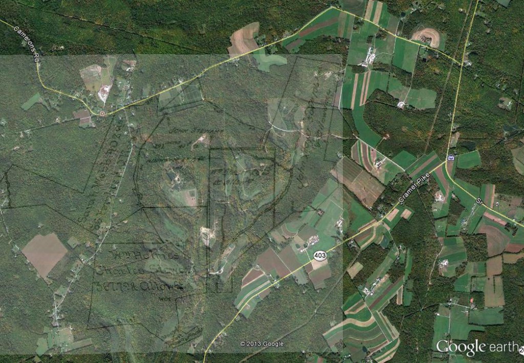
An 1871 map6 likely shows the Stewart homestead, although by that time it belonged to one of his heirs.
When I added that map as an overlay, the homestead itself appears near the central region of the property.
Google Earth is a useful tool to superimpose an old metes and bounds survey. You simply have to hunt for additional clues to pinpoint its actual location. I did this by looking at neighboring surveys and old maps of the region. The result is promising.
Footnotes- Pennsylvania, “Copied Surveys, 1681-1912,” database and digital images, Pennsylvania State Archives, Land Records (http://www.portal.state.pa.us/portal/server.pt/community/state_archives/2887 : downloaded 9 December 2009), RG-17, Series #17.114, Copied Survey Book C-206, Page 221 and reverse, John Stewart, http://www.phmc.state.pa.us/bah/dam/rg/di/r17-114CopiedSurveyBooks/Books%20C1-C234/Book%20C206/Book%20C-206%20pg%20441.pdf; Pennsylvania Historical and Museum Commission, Bureau of Archives and History.
- The warrant was number S-426.
- The survey is recorded in Survey Copy Book C-206, page 221.
- The land patent was recorded in Patent Book Volume P, Number 35, page 245.
- http://nationalmap.gov/viewer.html
- “State and County Maps: Pennsylvania: County Maps and Atlases,” map images, USGenWeb Archives, United States Digital Map Library (http://www.usgwarchives.org/maps/pa/county/: downloaded 9 December 2009), Map of Buffington Township, Indiana, Pennsylvania; citing Atlas of Indiana County Pennsylvania, (New York: F.W. Beers & Co., 1871).

My Name is Randee Allison Jones..My Grandfather is James Richard Stewart… my Great Grandfather is Joshua Thompson Stewart. How are you related to me???
Hi Randee, Your great-grandfather, Joshua Thompson Stewart, was a brother of my great-grandfather, John Galbreath Stewart. So we share ancestry back through James Stewart and Elizabeth Jane (Cole) Stewart. The homestead I discuss above is part of your heritage too.
Is this the same old Stewart Homestead that William Stewart had? James Henry Stewart Sr’s father?
I don’t see a match. Perhaps that is a different Stewart family.